Spatio-Temporal Issues in Infrastructure Lifecycle Management Systems
There is much information needed to manage the activities and events
that occur throughout the lifecycle of an infrastructure system, such
as a bridge, including construction and maintenance activities,
inspection data, environmental effects, etc. Conventional
infrastructure management systems provide only limited support for
representing and visualizing the spatio-temporal relationships within
this information. This paper discusses the spatio-temporal issues in
infrastructure lifecycle management systems. We start by discussing the
requirements for building these systems, such as the integration of
information from all stages of the lifecycle, including design,
construction, inspection and maintenance; the needs to exchange and
share this information across disciplines using standard
representation; data models and visualization requirements of 3D and 4D
models; and the interaction requirements when using these systems. Then
we propose to use an object-relational data model to represent the
spatio-temporal data and to base this model on Industrial Foundation
Classes (IFC) allowing multiple views of the model. We also discuss a
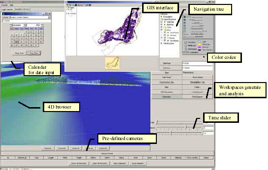
prototype system developed in Java language to demonstrate the proposed
approach using the data of Jacques Cartier Bridge in Montreal.
Different data types are integrated to build the spatio-temporal model
including CAD data, digital maps, and digital elevation models. The 3D
bridge model is linked with different scales of space and time to
record events throughout the lifecycle with suitable levels of details.
A friendly user interface is designed to retrieve and display
scheduling and inspection information directly on the 3D bridge model.